Our paper list is full of classic paleoseismic trenching studies from all over the world – fascinating to see how quickly the number of trenches is rising. We also have papers on tools & methodology, and on earthquake proxies that open new possibilities to study past large events. Don’t miss Ferrario et al. who compiled 15 years of research on earthquake environmental effects!
Another month has passed, new studies on earthquakes and active tectonics have been published. Enjoy reading! By the way: Registration for the PATA Days in France is now open, but you’ll have to hurry: https://patadays-2022.sciencesconf.org/
Hungary plans to build a new nuclear power plant (NPP) at the banks of the Danube near Paks, where another NPP is already running for several decades. An interesting story is currently unfolding around the geological site conditions, and this story includes paleoseismology. In short, the Austrians and external experts argue the planned NPP Paks II will sit on a capable fault, while the Hungarians say there is a fault, but it can’t rupture the surface. Actually, it’s a bit more complicated…
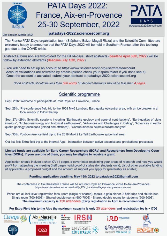
Here is the 2nd circular for the PATA Days in Southern France, September 2022. First important deadline: 30 April for submitting the short abstract (300 words). For more information visit http://patadays-2022.sciencesconf.org
INQUA’s XXI congress will take place in Rome in 2023. This is the most important gathering for the Quaternary community, taking place every four years only. Active tectonics, paleoseismology and related fields have found their home in INQUA’s TERPRO Commission (Terrestrial Processes, Deposits & History). TERPRO provides support for scientific meetings and networking; they have always been involved in the PATA Days and supported dozens of early career researchers and researchers from developing countries with travel grants for these meetings. If you want to support the earthquake community within INQUA, please join TERPRO here. It’s free and comes without obligations. It only means you’ll receive the INQUA newsletters, you can apply for funding for meetings and workshops (as an organiser), and you can elect the TERPRO officers.
Currently, the organising committee of the INQUA Congress in Rome is accepting session proposals for the 2023 congress. Please make sure your areas of interest are represented at the conference. If in doubt, contact your TERPRO officers. Let’s present some great earthquake science at INQUARoma2023!
These are the latest papers on paleoseismology, active tectonics, and archaeoseismology. Don’t forget to save the date for the Pata Days in France: 26-30 September, 2022. http://pata-days.org/
A Special Issue is now open for submissions in the journal Land. The topic is “Historical Data for Natural Hazard Risk Mitigation and Land Use Planning“. Deadline for manuscript submissions is 30 September 2022. Guest editors: Fabio Luino, Mariano Barriendos Vallvé, Emmanuel Garnier, Fabrizio Terenzio Gizzi, Ruediger Glaser, Christoph Gruetzner, Walter Palmieri, Sabina Porfido, Heather Sangster, and Laura Turconi.
Here we are with the latest list of papers on paleoseismology and active tectonics, and we start with a surprise: A published paper on the 8 January 2022 Ms 6.9 Menyuan earthquake! A mere three weeks after the event, Yang et al. have already managed to get their rapid report accepted. Spoiler: It includes an offset animal footprint trace in snow! But there’s a lot of other interesting stuff in the list, too – check it out!
Which journals do we normally chose for a neotectonics or paleoseismology paper? Sounds like a simple question, but the answer is not straight forward. Often, local journals are a great place, such as The New Zealand Journal of Geology and Geophysics, or society journals such as SRL, BSSA, and Quaternary International. Then there are the usual suspects: JGR, GJI, Tectonics, Tectonophysics, Geomorphology. If the story is a bit bigger we often go for EPSL or even the 4-page journals. Recently, several new players have appeared such as Frontiers or Scientific Reports, and I am also closely following the new diamond open access initiatives We Are Seismica and We Are Tektonika. In 1986, Wiley made an attempt to collect these kinds of studies in one place and launched NEOTECTONICS. Sadly, the journal only saw one single issue and was then discontinued. Today, you don’t find a trace of this journal any more, and searching for the single papers of the issue does not yield any results. Alan Nelson made me aware of the existence of this journal and somehow a copy found its way onto my desk. Here’s the list of papers that was published in the most exclusive of all neotectonics journals: